Climate Change, Snowmelt, and Salmon: WWU Faculty Probe for Answers on How to Save a Pacific Northwest Icon
Jim Helfield is in a race against time, and he knows it.
Helfield, an associate professor of Environmental Science at Western Washington University, is researching ways improve the habitat for spring- and summer-run Chinook salmon on the South Fork of Whatcom County’s Nooksack River. Also known as king salmon, Chinook are the largest Pacific salmon species, growing to sizes upwards of 100 pounds in some rivers.
In conjunction with colleagues in the Nooksack Tribe, Helfield is measuring how large, engineered logjams, placed systematically up and down the South Fork, change the river’s topography and form deep pools for the Chinook to rest and shelter in on their way to their breeding grounds upstream.
“These summer-run Chinook already have a tough task ahead of them,” Helfield said. “They enter the river at a time when its flows are at their lowest and its temperatures are at their highest. When temperatures get above 16 degrees Celsius or so (about 60 degrees Fahrenheit), they really start having a tough time and mortality rates jump. So we are trying to build these deep pools for them to rest in and sort of leapfrog their way upstream.”
These summer-run Chinook already have a tough task ahead of them. They enter the river at a time when its flows are at their lowest and its temperatures are at their highest.
Fisheries biologists with the tribe have built scores of the large logjams, and more are planned. Helfield plants temperature loggers each summer to gather temperature data above, below and in the pools; checks the temperatures to see if the river’s action of scouring the pools is also causing an upwelling of cool, beneficial groundwater through a process called hyporheic exchange; and just as importantly, also surveys to see how or if the logjams are being used by Chinook and other salmonids.
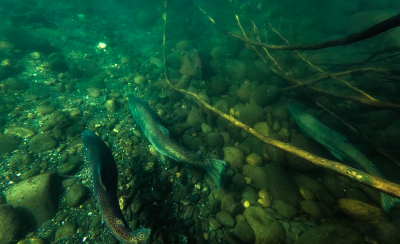
So far, the results are very positive.
“The vast majority of the early Chinook on the South Fork are using these structures, which is very encouraging,” he said. “In addition, the young salmon that emerge from the gravel are using these structures as shelters as well, going back deep into the root balls and using them to avoid predators.”
But this is where the race against time comes in: water temperatures on the South Fork are only going to get higher.
Unlike the North Fork and Middle Fork of the river, which are fed by glaciers from Mount Baker and Mount Shuksan, the South Fork is fed entirely by snowfields from the Twin Sisters, a massive slab of upthrust rock separated from Mount Baker by the Middle Fork valley.
And according to research by Helfield’s colleague Robert Mitchell, a professor of Geology at Western who specializes in watershed hydrology and numerical modeling, the planet’s rapidly climbing temperatures will in all probability mean far less snow in those snowfields, and thus higher summer water temperatures and lower stream levels.
“As anyone who lives around here knows, we’re often right at that temperature point where incoming storms could be either rain or snow. And sure, in the middle of the winter, during the coldest months, precipitation falling at elevation on the Sisters will fall as snow. But whereas historically we might have seen a lot of additional snowfall in the fall and spring, our numbers show that more than likely, a lot of that precipitation will increasingly fall as rain,” Mitchell said.
Mitchell gathers his data from a variety of established sources and runs 20 different meteorological scenarios, including best-case, worst-case and most-likely case examples, for the South Fork basin – and the results aren’t encouraging.
“It doesn’t take much of a nudge upwards in temperatures to have a pretty big impact on those snowfields,” he said, pointing to a map of the Sisters which shows current typical snow levels as large white patches on the upper half of the mountain. Under most future climate scenarios, the white areas of the map shrink drastically, meaning less snowmelt in the summer for the early Chinook.
“And while this is an issue for the salmon, it’s going to also be an issue for all the towns along the Nooksack in the fall and spring,” Mitchell said. “Because snow is stored liked a moisture bank in the winter. It releases slowly as it melts over the summer. Rainfall isn’t the same way; that moisture that falls as rain instead of snow presents a new problem for all the communities downstream in terms of potential flooding. And the reality is that the South Fork basin isn’t unique in this regard; many of the watersheds in Western Washington face this same kind of pressure.”
All of which makes Helfield feel a sense of urgency as he pauses on a South Fork gravel bar to look at a map with the locations for the next group of planned logjams. It is a sunny, gorgeous late summer day, the sky a cloudless, robin’s-egg blue, and Helfield has just seen a big Chinook making its way upstream.
“Sometimes it feels like we’re fighting a losing battle,” he said, watching the v-shaped wake of the large fish. “Other times, there’s reason for hope – you come out here on a day like today and see these logjams that we’ve built, and these huge salmon hiding down in them, and you feel like there are reasons to be optimistic as well. Time will tell. But in the meantime, we’re going to keep working.”
For more information on Helfield’s work, contact him at (360) 650-7285. For more on information on his climate-data forecasting work, contact Robert Mitchell at (360) 650-3591.